SUMMARY
This is AI generated summarization, which may have errors. For context, always refer to the full article.
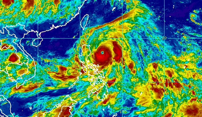
MANILA, Philippines – The state weather bureau raised Signal No. 3 due to Typhoon Egay (Doksuri) for the first time on Monday evening, July 24, as the tropical cyclone continued to intensify over the Philippine Sea.
Egay now has maximum sustained winds of 165 kilometers per hour from the previous 155 km/h, said the Philippine Atmospheric, Geophysical, and Astronomical Services Administration (PAGASA) in a briefing past 11 pm on Monday.
The typhoon’s gustiness is now up to 205 km/h from 190 km/h.
It was already 425 kilometers east northeast of Baler, Aurora, or 365 kilometers east of Casiguran, Aurora, late Monday evening.
Egay slightly accelerated, still moving north northwest but at 15 km/h from only 10 km/h.
Below is the list of areas under tropical cyclone wind signals as of 11 pm on Monday.
Signal No. 3
Storm-force winds (89 to 117 km/h), moderate to significant threat to life and property
- eastern part of mainland Cagayan (Santa Ana, Gonzaga, Peñablanca, Baggao, Gattaran, Lal-lo)
- northeastern part of Isabela (Divilacan, Maconacon)
Signal No. 2
Gale-force winds (62 to 88 km/h), minor to moderate threat to life and property
- Batanes
- Babuyan Islands
- rest of mainland Cagayan
- rest of Isabela
- Quirino
- northern part of Nueva Vizcaya (Kasibu, Quezon, Diadi, Bagabag, Ambaguio, Villaverde, Solano, Bayombong)
- Apayao
- Kalinga
- Abra
- Mountain Province
- Ifugao
- northern part of Benguet (Bakun, Mankayan, Buguias, Kabayan, Kibungan)
- Ilocos Norte
- Ilocos Sur
- northern and central parts of Aurora (Dilasag, Casiguran, Dinalungan, Dipaculao)
Signal No. 1
Strong winds (39 to 61 km/h), minimal to minor threat to life and property
- La Union
- Pangasinan
- rest of Benguet
- rest of Nueva Vizcaya
- rest of Aurora
- Zambales
- Bataan
- Nueva Ecija
- Tarlac
- Pampanga
- Bulacan
- Metro Manila
- Rizal
- Laguna
- Cavite
- Batangas
- Quezon
- Marinduque
- central and eastern parts of Romblon (Banton, Corcuera, Romblon, Magdiwang, Cajidiocan, San Fernando)
- Camarines Norte
- Camarines Sur
- Catanduanes
- Albay
- Sorsogon
- Masbate
- Northern Samar
- northern and central parts of Samar (Almagro, Tagapul-an, Santo Niño, Daram, Zumarraga, Villareal, Talalora, Hinabangan, Calbiga, Pinabacdao, Paranas, Motiong, San Sebastian, Jiabong, Catbalogan City, San Jose de Buan, Matuguinao, San Jorge, Tarangnan, Gandara, Pagsanghan, Santa Margarita, Calbayog City)
- northern and central parts of Eastern Samar (Borongan City, San Julian, Sulat, Taft, Can-avid, Oras, Arteche, Jipapad, Dolores, San Policarpo, Maslog)
- Biliran
The highest possible wind signal is either Signal No. 4 or 5.
PAGASA also updated its rainfall forecast for Egay for the next three days. It again warned affected areas that floods and landslides are highly likely.
Monday evening, July 24, to Tuesday evening, July 25
- 100-200 millimeters (mm): northeastern part of mainland Cagayan
- 50-100 mm: Batanes, Babuyan Islands, rest of mainland Cagayan, Isabela, Apayao, Abra, Ilocos Norte, Ilocos Sur, La Union, Catanduanes, Camarines Norte, Camarines Sur, Albay
Tuesday evening, July 25, to Wednesday evening, July 26
- Above 200 mm: Batanes, Babuyan Islands, northeastern part of mainland Cagayan, Ilocos Norte, Ilocos Sur, Apayao, Abra
- 100-200 mm: rest of Cagayan, western part of Kalinga, western part of Mountain Province, western part of Benguet, La Union, northwestern part of Pangasinan
- 50-100 mm: northern part of Isabela, rest of Kalinga, rest of Mountain Province, rest of Benguet, western part of Ifugao, rest of Pangasinan
Wednesday evening, July 26, to Thursday evening, July 27
- 50-100 mm: Batanes

The weather bureau warned as well that there is now a high risk of storm surges which may cause floods in the low-lying and exposed coastal areas of the following provinces:
- Batanes
- Cagayan
- Isabela
- Ilocos Norte
- extreme northern part of Ilocos Sur
“Maximum surge heights may reach 2 meters in most of the warning areas, with some localities exceeding 2-meter surge heights,” PAGASA said.
For coastal waters, the gale warning issued at 5 pm on Monday remains in effect. Rough to very rough seas are expected in these seaboards:
- seaboards of Northern Luzon, eastern seaboards of Central Luzon and Southern Luzon, eastern seaboard of Visayas (Ilocos Norte, Batanes, Cagayan including Babuyan Islands, Isabela, Aurora, Catanduanes, eastern coast of Camarines Sur, eastern coast of Albay, Northern Samar) – waves 3.1 to 6 meters high
- seaboards of Southern Luzon, eastern and central seaboards of Visayas (Camarines Norte, Quezon including Polillo Islands, rest of Camarines Sur, rest of Albay, Sorsogon, Masbate including Ticao and Burias islands, Marinduque, Romblon, Eastern Samar, Samar, Biliran, Leyte, northern coast of Cebu) – waves 3.1 to 6 meters high
- western seaboard of Southern Luzon, seaboards of Central Visayas and Western Visayas (Bohol, rest of Cebu, Negros Oriental, Negros Occidental, Guimaras, Iloilo, Capiz, Aklan, Antique, Occidental Mindoro, Palawan including Calamian, Cuyo, and Kalayaan Islands) – waves 2.8 to 4.5 meters high
- eastern seaboard of Mindanao (eastern coast of Surigao del Norte including Siargao and Bucas Grande islands, Dinagat Islands) – waves 2.8 to 4.5 meters high
“Sea travel is risky for small seacraft. For larger vessels, operating in gale conditions requires experience and properly equipped vessels. Mariners without proper experience or operating ill-equipped vessels are advised to remain in port or seek safe harbor,” PAGASA said.
The typhoon might also cause moderate to rough seas in coastal waters along the western, northern, and eastern seaboards of Mindanao not covered by the gale warning. Small vessels should take precautionary measures as waves may be 2 to 3.5 meters high.
Meanwhile, Egay is still enhancing the southwest monsoon or habagat, which will continue to trigger rain in the western parts of Central Luzon, Southern Luzon, and the Visayas in the next three days.
Gusty conditions, still due to the enhanced southwest monsoon, may persist in these areas as well:
Tuesday, July 25
- Luzon, Visayas, Zamboanga Peninsula, Basilan, Sulu, Tawi-Tawi, northern part of Northern Mindanao, northern part of Caraga
Wednesday, July 26
- Luzon, Visayas, Zamboanga Peninsula
Thursday, July 27
- Luzon, Western Visayas
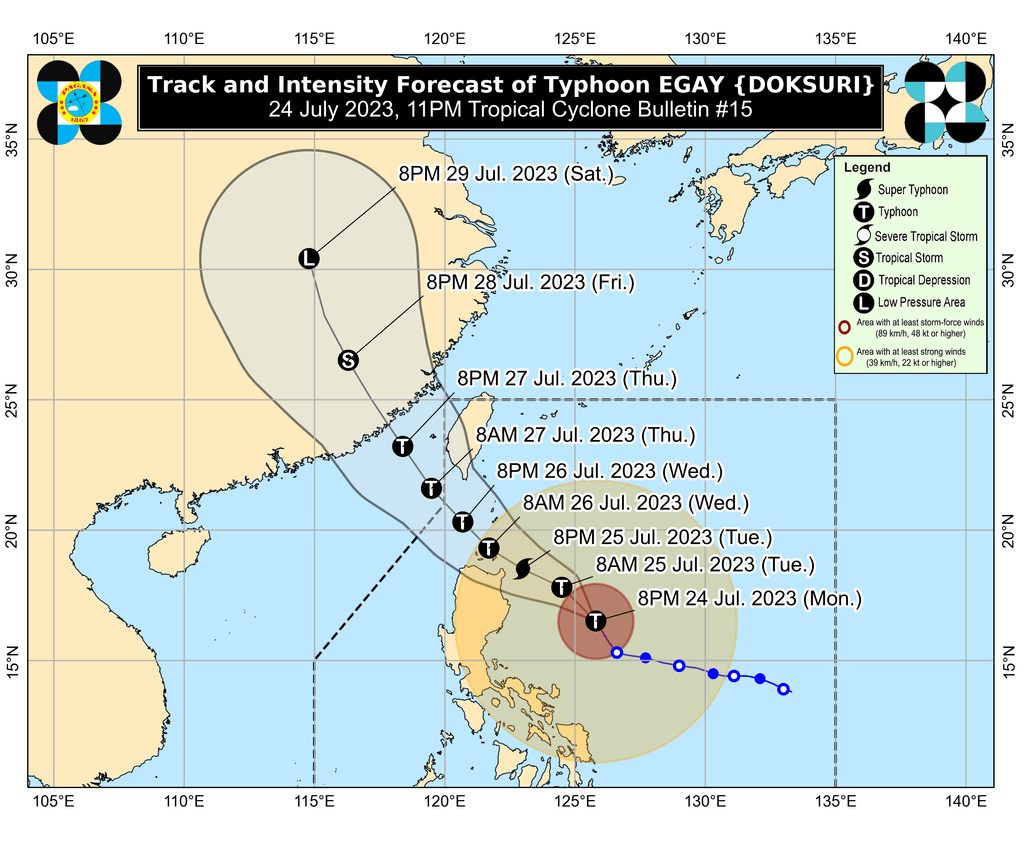
PAGASA sees Egay moving northwest until Tuesday morning, July 25, then turning west northwest and crossing the Luzon Strait.
The typhoon could make landfall in or pass very close to Cagayan province’s Babuyan Islands on Wednesday, July 26, between early morning and afternoon.
But a “slight northward or southward shift in this segment of the track may result in a landfall or close approach over northern mainland Cagayan or Batanes,” according to the weather bureau.
After passing the Babuyan Islands, Egay may turn northwest or north northwest and pass over the waters south of Taiwan, which is within the Philippine Area of Responsibility (PAR).
The typhoon could leave PAR on Wednesday evening or Thursday morning, July 27. Then it would cross the Taiwan Strait and make landfall in Fujian, China, on Thursday evening or Friday morning, July 28.
Egay is also expected to strengthen into a super typhoon on Tuesday. But if its track shifts closer to Luzon landmass, it may “peak at an intensity just below super typhoon threshold,” or just below 185 km/h.
PAGASA also said Egay may start weakening as it passes over the Babuyan Islands “due to the potential onset of [an] eyewall replacement cycle and interaction with the rugged terrain of Northern Luzon.”
Further weakening is likely outside PAR due to an “increasingly unfavorable environment” and the tropical cyclone’s potential landfall in China.
Egay is the Philippines’ fifth tropical cyclone for 2023 and the second for July. PAGASA earlier estimated that two to four tropical cyclones would form inside or enter PAR during the month. – Rappler.com
Add a comment
How does this make you feel?


There are no comments yet. Add your comment to start the conversation.