SUMMARY
This is AI generated summarization, which may have errors. For context, always refer to the full article.

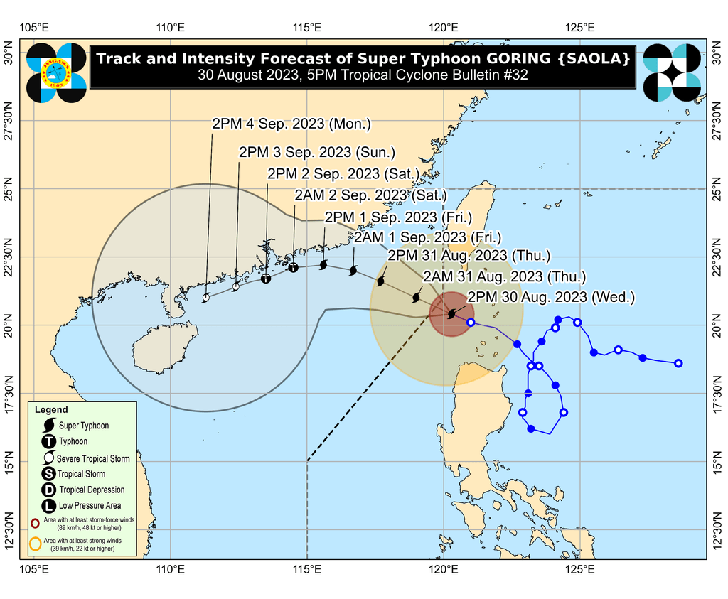
MANILA, Philippines – Super Typhoon Goring (Saola) was approaching the northwestern boundary of the Philippine Area of Responsibility (PAR) on Wednesday afternoon, August 30, about to exit within hours.
In a briefing past 5 pm on Wednesday, the Philippine Atmospheric, Geophysical, and Astronomical Services Administration (PAGASA) said Goring was already 185 kilometers west of Itbayat, Batanes.
The super typhoon is still moving west northwest at 15 kilometers per hour (km/h). At that rate, it will leave PAR on Wednesday night or Thursday morning, August 31.
Goring also maintains maximum sustained winds of 195 km/h and gustiness of up to 240 km/h. PAGASA said it is likely to remain a super typhoon until Friday, September 1.
Goring brought torrential rain and fierce winds to parts of Northern Luzon even though it did not make landfall. It has also been enhancing the southwest monsoon or habagat.
Rain from the super typhoon will gradually ease, but PAGASA warned that there may still be moderate to intense rain in the coming hours.
- 100-200 mm: Batanes, Babuyan Islands, Ilocos Norte, northern part of Apayao, extreme northwestern part of mainland Cagayan
- 50-100 mm: Ilocos Sur, Abra, rest of Apayao, northwestern part of mainland Cagayan
There also remains a “moderate to high risk” of storm surges, “which may cause flooding in the low-lying and exposed coastal areas of Batanes and the northern and western portions of Babuyan Islands.”
As for strong winds, Signal No. 2 was already lifted as of 5 pm on Wednesday. But the following areas remain under Signal No. 1:
- Batanes
- Babuyan Islands
- Ilocos Norte
- northern part of Apayao (Luna, Santa Marcela, Calanasan)
- northwestern part of Cagayan (Pamplona, Claveria, Ballesteros, Abulug, Sanchez Mira, Santa Praxedes)
ALSO ON RAPPLER
- Marcos, other PH officials pay tribute to journalism pillar Mike Enriquez
- QCPD chief resigns amid road rage controversy
- LIVE UPDATES: FIBA World Cup 2023 – August 30 games
- Italy coach tells winless Gilas Pilipinas to be proud, praises Jordan Clarkson for ‘amazing behavior’
- REVIEW: Shorts and Briefs’ ‘Ang Tigas ng Ulo Mo,’ ‘Bakit Bata,’ ‘Homecoming,’ ‘Mga Nakasusuyang Putahe’
Earlier on Wednesday, PAGASA warned that rain from the enhanced southwest monsoon may persist for a few more days.
Wednesday, August 30
- 100-200 mm: Zambales, Bataan, northern part of Palawan including Calamian and Cuyo islands, Occidental Mindoro
- 50-100 mm: Metro Manila, Pangasinan, La Union, Benguet, southern part of Palawan including Cagayancillo, Antique, Negros Occidental, Guimaras
Thursday, August 31
- 100-200 mm: Zambales, Bataan, Occidental Mindoro
- 50-100 mm: Metro Manila, Rizal, Bulacan, Cavite, Batangas, northern part of Palawan including Calamian and Cuyo islands
Friday, September 1
- 100-200 mm: Zambales, Bataan, Pangasinan, Occidental Mindoro
- 50-100 mm: Metro Manila, Rizal, Cavite, Batangas, Bulacan, Nueva Ecija, La Union, Benguet
The enhanced southwest monsoon is triggering gusty conditions in these areas as well:
Wednesday, August 30
- Ilocos Region, Cordillera Administrative Region, Zambales, Bataan, Bulacan, Aurora, Metro Manila, Calabarzon, Mimaropa, Bicol, Western Visayas
Thursday, August 31, and Friday, September 1
- Ilocos Region, Cordillera Administrative Region, Zambales, Bataan, Bulacan, Pampanga, Aurora, Metro Manila, Calabarzon, Mimaropa, Bicol, Western Visayas

Goring and the enhanced southwest monsoon continue to affect the country’s coastal waters as well. PAGASA issued another gale warning at 5 pm on Wednesday, covering these seaboards:
- northern seaboard of Northern Luzon (Batanes, northern coast of Ilocos Norte, northern coast of Cagayan including Babuyan Islands) – rough to high seas, with waves 3.1 to 7.5 meters high
- western seaboard of Northern Luzon and Central Luzon (western coast of Ilocos Norte, Ilocos Sur, La Union, Pangasinan, Zambales, Bataan) – rough to very rough seas, with waves 2.8 to 4.5 meters high
- western and southern seaboards of Southern Luzon, western seaboard of Visayas (Metro Manila, Cavite, Batangas, Oriental Mindoro, Occidental Mindoro, Marinduque, Romblon, Palawan, Aklan, Antique, Capiz, Iloilo, Guimaras, Negros Occidental) – rough to very rough seas, with waves 2.8 to 4.5 meters high
- eastern seaboard of Northern Luzon and Central Luzon, seaboards of Quezon and Bicol (eastern seaboard of Cagayan, Isabela, Aurora, northern Quezon, southern Quezon, Camarines Norte, Camarines Sur, Catanduanes, Albay, Sorsogon, Masbate) – rough to very rough seas, with waves 2.8 to 4.5 meters high
- central and eastern seaboards of Visayas, eastern seaboard of Mindanao (Negros Oriental, Cebu, Bohol, Siquijor, Northern Samar, Eastern Samar, Samar, Biliran, Leyte, Southern Leyte, Dinagat Islands) – rough to very rough seas, with waves 2.8 to 4.5 meters high
The weather bureau advised fishing boats and other small vessels not to sail, and larger vessels to watch out for big waves.
After Goring’s expected exit from PAR on Wednesday night or Thursday morning, it is projected to head west northwest for the rest of Thursday before shifting toward the west on Friday, then west southwest on Saturday, September 2.
It may move “nearly parallel to the coast of Guangdong, China,” but PAGASA said landfall is possible in mainland China on Sunday, September 3.
“Increasingly unfavorable conditions over the waters off the coast of Guangdong will trigger a weakening trend and by Monday (September 4), Goring will have weakened into a severe tropical storm,” added the weather bureau.
Goring is the Philippines’ seventh tropical cyclone for 2023 and the first for August. It is also the third super typhoon for the year, after Betty (Mawar) in May and Egay (Doksuri) in July.
PAGASA previously said it expects two or three tropical cyclones to develop within or enter PAR in August.
Severe Tropical Storm Haikui will be the second tropical cyclone for the month, as it is set to enter PAR on Wednesday evening. Its local name would be Hanna.
Haikui was last spotted 1,380 kilometers east of extreme Northern Luzon at 3 pm on Wednesday, moving west northwest at 15 km/h.
The severe tropical storm slightly weakened, with its maximum sustained winds down to 100 km/h from 110 km/h. Its gustiness also eased to 125 km/h from 135 km/h.
Haikui or the potential Hanna is seen to remain far from Philippine landmass, which means it is “less likely to directly affect the country.” But PAGASA warned that it could enhance the southwest monsoon. – Rappler.com
Add a comment
How does this make you feel?


There are no comments yet. Add your comment to start the conversation.