SUMMARY
This is AI generated summarization, which may have errors. For context, always refer to the full article.
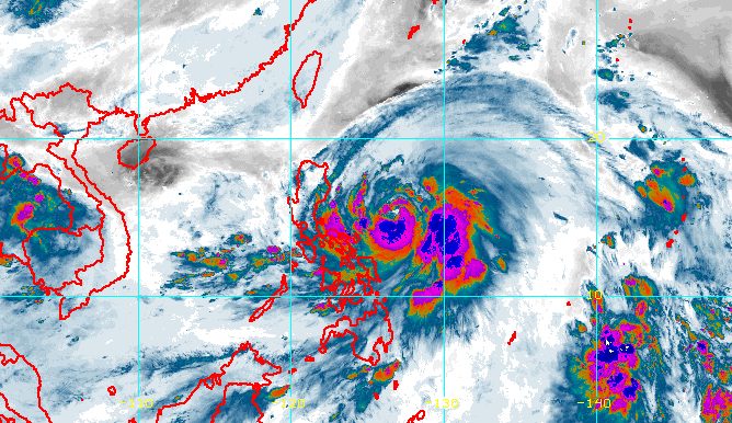
MANILA, Philippines – Typhoon Egay (Doksuri) underwent rapid intensification while moving over the Philippine Sea, the country’s weather bureau said early Monday, July 24.
Egay’s maximum sustained winds increased further from 120 kilometers per hour to 140 km/h, according to the 5 am bulletin of the Philippine Atmospheric, Geophysical, and Astronomical Services Administration (PAGASA).
The typhoon’s gustiness is now up to 170 km/h from the previous 150 km/h.
It was last spotted 565 kilometers east of Baler, Aurora, now moving west at a slightly faster 15 km/h from 10 km/h.
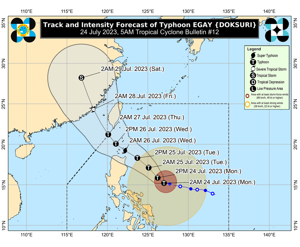
“After a brief period of westward or west northwestward movement, Egay is forecast to turn northwestward and head closer to the landmass of Northern Luzon towards the Luzon Strait,” PAGASA said.
Egay could then cross the Luzon Strait and make landfall in or pass very close to the Babuyan Islands-Batanes area between late Tuesday evening, July 25, and Wednesday afternoon, July 26.
But PAGASA also emphasized that a further shift in Egay’s track – closer to Luzon – remains possible “due to the persistence of the ridge of high pressure north of the typhoon.” This ridge has been influencing Egay’s movement.
“As such, a landfall over the northeastern portion of mainland Cagayan is not ruled out,” the weather bureau said.
PAGASA also sees Egay strengthening further and becoming a super typhoon by late Tuesday or early Wednesday. But if its track shifts closer to Luzon landmass, it may “peak at an intensity just below super typhoon threshold,” or just below 185 km/h.
“Nevertheless, Egay is forecast to become a very strong typhoon,” the weather bureau warned.
More areas were placed under tropical cyclone wind signals as of 5 am on Monday:
Signal No. 2
Gale-force winds (62 to 88 km/h), minor to moderate threat to life and property
- southeastern part of Isabela (Palanan, Dinapigue)
- northeastern part of Catanduanes (Pandan, Bagamanoc, Panganiban, Viga, Gigmoto)
Signal No. 1
Strong winds (39 to 61 km/h), minimal to minor threat to life and property
- Batanes
- Cagayan including Babuyan Islands
- rest of Isabela
- Quirino
- Nueva Vizcaya
- Apayao
- Kalinga
- Abra
- Mountain Province
- Ifugao
- Benguet
- Ilocos Norte
- Ilocos Sur
- La Union
- northern part of Pangasinan (Natividad, San Nicolas, San Quintin, Sison, Pozorrubio, San Manuel, San Fabian, Anda, Bolinao, San Jacinto, Manaoag, Laoac, Binalonan, Asingan, Tayug, Santa Maria, Umingan, Dagupan City, Mangaldan)
- Aurora
- northern and eastern parts of Nueva Ecija (Carranglan, Bongabon, Gabaldon, Pantabangan, Lupao, San Jose City)
- northern and southeastern parts of Quezon (Pitogo, San Andres, Buenavista, San Francisco, Calauag, Infanta, Lopez, Catanauan, Mulanay, Guinayangan, Unisan, General Luna, Plaridel, Quezon, Alabat, Padre Burgos, Macalelon, Mauban, General Nakar, Perez, Agdangan, Gumaca, Atimonan, Real, San Narciso, Tagkawayan) including Polillo Islands
- Camarines Norte
- Camarines Sur
- rest of Catanduanes
- Albay
- Sorsogon
- Masbate
- Northern Samar
- Eastern Samar
- Samar
- Biliran
The highest possible wind signal is either Signal No. 4 or 5.
PAGASA also updated its rainfall forecast for Egay, expanding the list of areas expected to see heavy rain:
Monday, July 24
- 50-100 millimeters (mm): Catanduanes, northeastern part of Camarines Sur, northern part of Camarines Norte
Tuesday, July 25
- Above 200 mm: northeastern part of mainland Cagayan
- 100-200 mm: rest of Cagayan including Babuyan Islands, Ilocos Norte, Ilocos Sur, western part of Abra, northern part of Apayao
- 50-100 mm: Batanes, northern and eastern parts of Isabela, rest of Apayao, rest of Abra, Kalinga, western part of Mountain Province, Benguet, La Union, western part of Pangasinan
Wednesday, July 26
- Above 200 mm: Batanes, Babuyan Islands, Ilocos Norte
- 100-200 mm: northern part of mainland Cagayan, Apayao, Abra, Ilocos Sur
- 50-100 mm: rest of mainland Cagayan, Kalinga, western part of Mountain Province, Benguet, La Union, Pangasinan
The weather bureau warned that floods and landslides are highly likely.

PAGASA issued a new gale warning for Egay at 5 am on Monday, covering the following seaboards which have rough to very rough seas:
- eastern seaboards of Northern Luzon and Southern Luzon (Batanes, Cagayan including Babuyan Islands, Isabela, Camarines Norte, Camarines Sur, Catanduanes, Albay, Sorsogon) – waves 3.1 to 5.5 meters high
- eastern seaboards of Central Luzon and Southern Luzon (Aurora, Quezon including Polillo Islands) – waves 2.8 to 5 meters high
- southern seaboard of Southern Luzon as well as eastern seaboards of the Visayas and Mindanao (Marinduque, Romblon, Masbate including Ticao and Burias Islands, Northern Samar, Eastern Samar, eastern coast of Surigao del Norte including Siargao and Bucas Grande islands, Dinagat Islands) – waves 2.8 to 4.5 meters high
“Sea travel is risky for small seacraft. For larger vessels, operating in gale conditions requires experience and properly equipped vessels. Mariners without proper experience or operating ill-equipped vessels are advised to remain in port or seek safe harbor,” the weather bureau said.
The typhoon might also cause moderate to rough seas in the western and southern seaboards of Southern Luzon, the remaining seaboards of the Visayas, and the eastern seaboard of Mindanao not covered by the gale warning. Small vessels should take precautionary measures as waves may be 2 to 3 meters high.
Egay is also enhancing the southwest monsoon or habagat, which will continue to affect Southern Luzon, the Visayas, and Mindanao on Monday.
Rain from the enhanced southwest monsoon may be more concentrated in these areas:
Sunday night, July 23, to Monday night, July 24
- 50-100 mm: northern part of Palawan including Cuyo and Calamian islands, Occidental Mindoro, Antique
Monday night, July 24, to Tuesday night, July 25
- 50-100 mm: Zambales, Bataan, Occidental Mindoro, northern part of Palawan including Cuyo, Calamian, and Cagayancillo islands, Western Visayas, Negros Oriental
Tuesday night, July 25, to Wednesday night, July 26
- 50-100 mm: Zambales, Bataan, Occidental Mindoro, northern part of Palawan including Cuyo, Calamian, and Cagayancillo islands, Western Visayas
PAGASA maintained that Metro Manila will only have isolated rain showers or thunderstorms on Monday, when President Ferdinand Marcos Jr. will deliver his second State of the Nation Address. Note, however, that flash floods are possible during severe thunderstorms.
Gusty conditions due to the enhanced southwest monsoon could also persist in the next three days:
Monday, July 24
- Calabarzon, Mimaropa, Visayas, and northern parts of Zamboanga Peninsula, Northern Mindanao, Caraga
Tuesday, July 25
- Luzon, Visayas, Zamboanga Peninsula, Basilan, Sulu, Tawi-Tawi, northern part of Northern Mindanao, Dinagat Islands
Wednesday, July 26
- Luzon, Visayas
The weather bureau said Egay is projected to leave the Philippine Area of Responsibility (PAR) on Thursday, July 27. Then it would cross the Taiwan Strait and make landfall in Fujian, China, late Thursday or early Friday, July 28.
Before Egay leaves PAR, it might start to weaken on Wednesday afternoon or evening “as it enters the cooler waters southwest and west of Taiwan.” Taiwan is within PAR.
Egay is the Philippines’ fifth tropical cyclone for 2023 and the second for July. PAGASA earlier estimated that two to four tropical cyclones would form inside or enter PAR during the month. – Rappler.com
Add a comment
How does this make you feel?


There are no comments yet. Add your comment to start the conversation.